I’ve recently found Mapillary which is a great project that aims to cover the world with street level photos, just like Google’s StreetView. The big difference is that they use the crowdsourcing approach and collect images from volunteers, mostly equipped with smartphones or action cameras. All photos are available under CC BY-SA 4.0. They process all uploaded photos using computer vision on their servers. They have a nice API so everything is given. They’re open, they’re geospatial and they’re nice. You can talk with them via Twitter or email. They’ll respond. Currently, you can find them in Malmö, Sweden and in West Hollywood, Los Angeles. The project pretty soon has gone worldwide. The service was initially released in the last week of February 2014 at the Launch Festival and since then they cover 101658370 meters with 3541820 uploaded photos until September 21. Check out their site and see what they are doing. From my sight, it’s pretty impressive. I’ve shot this panorama view in Key West, FL.
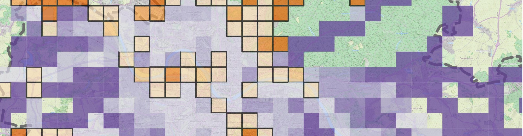
So, we have two applications of the same type. The methods and philosophy behind the scenes are different but the ultimate goal is the same – cover the world with street level photos. First idea is to compare them which is not necessarily easy due to legal and technical issues. I am working on developing a method to precisely compare them using map-matching algorithms but until then, I’ll present an online tool which plots the two data sources in the same map. Blue color shows the Google StreetView coverage by default. Zoom to a place in which you’re interested in and press the “Load Mapillary sequences!” button. In a few seconds – depending on how many sequences should be returned -, Mapillary data will be loaded into the map. The current approach will search for all sequences in a 0.07 x 0.07 degrees rectangle around the center through their API. Make sure to “set” the map center correctly. If you don’t see any red lines after a while, that should show the Mapillary coverage, that means that there’s probably no coverage for that area. Pan the map to another area and try again. Please note that this is just the product of few hours of hacking so it’s far from perfect. It was a good opportunity to try out the brand new OpenLayers 3 library and put Mapillary and StreetView together on a ‘live’ site. Give me some feedback and I’ll improve it if needed. Click here for the full screen application.
– Update 09/28 2014: Sorry, there are some strange issues with OpenLayers 3. Sometimes the map appears to be blank. I’ll switch to Leaflet sometime soon. Try reload the page in a different browser until then.
## After pressing the button it takes some time for Mapillary sequences (red lines) to be sown on the map. ##
– Update 03/31/2016: Don’t press anything. In fact, there are no buttons to press at all. I updated the page so now it’s utilizing vector tiles so everything should be loaded automatically. I still haven’t switched the mapping library to Leaflet, though. Expect unresponsive pages when looking at the map from overview zoom levels ;)


Pingback: weekly – 219 – 23.09. – 29.09.2014 | weekly – semanario – săptămânal – haftalık – 毎週
Pingback: weekly – 219 – 23.09.-29.09.2014 | weekly – semanario – săptămânal – haftalık – 毎週
Oh my goodness! Incredible article dude! Thank you,
However I am going through issues with your RSS.
I don’t understand the reason why I am unable to subscribe to it.
Is there anyone else getting the same RSS
issues? Anyone who knows the answer will you kindly respond?
Thanks!!
Hey, it’s quite possible that I didn’t set my RSS feed right. In fact, I don’t have notifications for comments either, that’s why I took so long to get back to you. Sorry for that.
Try putting the feed manually to your RSS reader. I think you should be able to do that using this link: http://blog.jlevente.com/feed/
Let me know how it goes. Also, I’m planning to rewrite the map for this page soon so it’s likely to change… In a matter of months, though :)
Thanks for passing by!
Your story was really inovmratife, thanks!
A remarkably helpful post!Yes, I have changed POV through for an entire manuscript. I've never regretted it. It automatically fixed pacing issues I was having, as well as characterization. Sometimes, the best thing to do is to just take that plunge and see how it goes.Of course, keep the original manuscript just in case. ;)
Hi Lemente,
Referring back to what you wrote about doing a more detailed comparison of coverage ( “I am working on developing a method to precisely compare them using map-matching algorithms”) – did you ever manage to do this? I’d be keen to compare coverage but also the freshness of the data? It would be interesting to see if Mapillary data is updated on a more regular basis given how easy it is to map and re-map an area.
Thanks!
Hey Sam,
Terribly sorry for the late response. I missed your comment completely. I published two articles on the topic. I developed a method that used raster tiles to compare coverage. It worked great, actually but it’s a bit troublesome to scale it. Given enough time, I’d like to modify that method and work with vector tiles with Mapbox’s tile-reduce tool. With these things, it’d be possible to compute coverage lightning fast for any given geographic areas – in case of Mapillary. For StreetView, it won’t work unfortunately as StreetView vector tiles are not available as far as I know.
If you’d like to read more about the original method I used, I recommend reading these articles (or shooting me an email).
Juhász, L. and Hochmair, H.H. (2016). User Contribution Patterns and Completeness Evaluation of Mapillary, a Crowdsourced Street Level Photo Service. Transactions in GIS. 20 (6): pp. 925–947 – https://www.researchgate.net/publication/291952220_User_Contribution_Patterns_and_Completeness_Evaluation_of_Mapillary_a_Crowdsourced_Street_Level_Photo_Service
Juhász, L. and Hochmair, H. H. (2015). Exploratory Completeness Analysis of Mapillary for Selected Cities in Germany and Austria. In A. Car, T. Jekel, J. Strobl and G. Griesebner (Eds.), GI_Forum 2015 – Geospatial Minds for Society (pp. 535-545). Berlin/Offenbach: Wichmann – https://www.researchgate.net/publication/280684552_Exploratory_Completeness_Analysis_of_Mapillary_for_Selected_Cities_in_Germany_and_Austria
Useful tool, but is it still working? Tried on both Edge and Chrome and I’m getting a blank screen.
Thanks
Thank you for sharing valuable information. Nice post. I enjoyed reading this post.