Category Archives: general

[Call for papers] Advances in Social Network Analysis – Spatio-Temporal and Semantic Methods

I am co-editing a Special Issue titled “Advances in Social Network Analysis – Spatio-Temporal and Semantic Methods” in the ISPRS International Journal of Geo-Information (IJGI) with Hartwig Hochmair (University of Florida) and Bernd Resch (University of Salzburg / Harvard University).

We’re expecting original contributions that address interesting questions using data from social media, location-based service (LBS) and volunteered geographic information (VGI) platforms. More info and submission form can be found on the IJGI website.

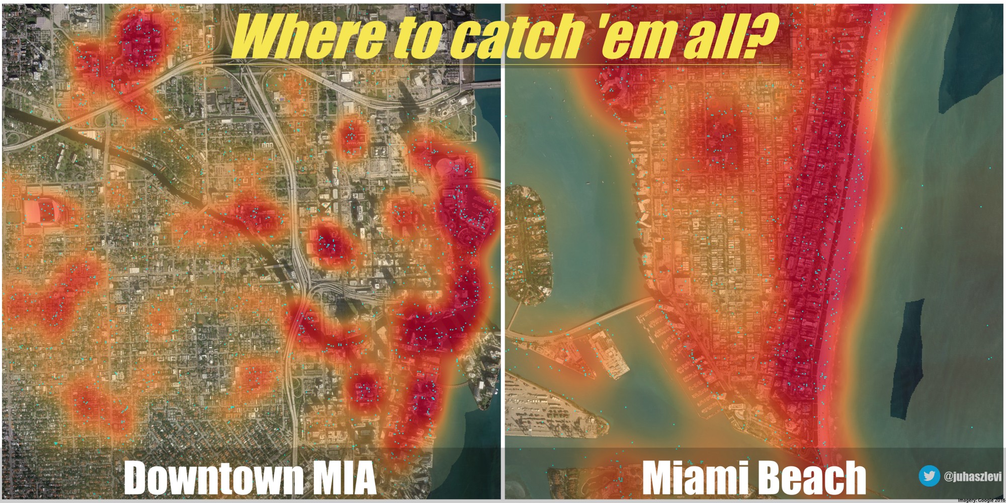
Where to catch ’em all?

I should really stop playing around with side projects and should get back to my research. But look at this! I recorded a few hundred thousand Pokemon encounters over the past few days. You know, just for fun, because that’s what grown ups do. I marked all Pokemon locations in Downtown Miami and Miami Beach with cyan dots and created a heatmap on top of them to see where you should wonder if you want to catch as many as you can.

Pokemon locations and density in Miami

Click for a high-res version.

To be honest, I don’t play Pokemon Go. Was never into this thing. But I do like maps and data. And this is really cool data. So, I’m thinking. Maybe. What if I made it my research… what if I could come up with something really interesting? Oh, well. Instead of trying to justify myself, I guess I’m just gonna catch ’em all along with some awesome spatial analysis.

Bulk import of Buildings in Miami-Dade

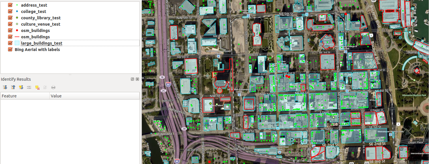
This Monday I attended my very first Maptime Miami Meetup where Matthew Toro talked about a potentially great addition to Miami’s OSM… buildings! What makes a map detailed and fancy looking? I think it’s buildings. And landuse. And POIs. Oh well, I could continue adding items to this list for days without even starting to talk about it, really. But in any case, buildings are without a doubt the very foundation of what we can call a detailed map. Sadly, Miami’s OSM is not what we can call nice and detailed in its current state. It instantly becomes clear when you look at the map that it needs some improvement. But you know what? That’s the fun part of collaborative mapping. It’s really up to us how we build a useful map database and how detailed we want it to be. It’s us, regular people who add restaurants, bike lanes, shops and many other things we care about. Long story short, the Meetup was about importing a publicly available building dataset and making it an integral part of OpenStreetMap. I’ve decided to participate in the process, and I planned to help out with some basic stuff, throwing some ideas, maybe writing some code. You know, nothing fancy. At least that’s what I imagined. But as things rarely turn out the way we want them, now I’m the tech lead on this. Big words, I know, but they’re not mine.

downtownMIA

Red outline: current OSM buildings. Cyan spots: buildings to be imported. Now, that’s a lot of new buildings to add!

Continue reading

Animated maps for Saturday

How long does it take to map an area with Mapillary? Well, apparently it’s up to you. According to he video below, it shouldn’t take long. It shows how street level photo coverage evolved in Phoenix, AZ between June 2015 and April 2016. I’m always amazed to see what can be achieved in just less than a year.

Videos were generated using the Time manager plugin of QGIS and Libav.

Hey, do you even map bro?

A year ago, high quality aerial imagery with a 10cm ground resolution was made available to the OSM community in Szeged, Hungary. It’s a very good example of not just sitting on the data but trying to make use of it. In theory, OpenStreetMap community can absolutely benefit from having a data source like this as there are way more details to be derived from such high resolution imagery. Also, the positional accuracy of the orthophoto is worth mentioning. You know, this is the kind of aerial photograph that you can make measurements on, like if it was a true map. It’s important because you can skip playing with different offsets and dragging your base map around to make it appear in its “true” position before you can actually start mapping. So, truth’s been told. It’s cool, but what the heck is with it?

Well, It’s been a year or so. I can talk about the benefits for days but it doesn’t really matter if no one is acting accordingly, right? There are things that “should” work in theory but when it comes to online communities… well, that’ a whole different story. Anyway, let’s lurk around and see what awesome mappers of OSM think about all this (oh, did I just say awesome people of OSM? Is it a spoiler? Oh well, I guess you have to click on the link below and read more to figure it out.)

szeged_orto_cover

Continue reading

The Book of OSM

Today, a new project appeared on Kickstarter from the founder of OpenStreetMap, Steve Coast. I highly encourage everyone (in case you can) to stand for it so we can enjoy some insights about OSM.  It’s pretty interesting how more than 1/5 of the goal have been pledged in less then 1 day.

In addition, enjoy a recent talk about the project.


MongoDB – PostgreSQL speed comparison

As the last part of the previous post-series about MongoDB and Twitter I’m about to show some plots about an initial speed comparison of the two DBs. As a result, these plots show how MongoDB can perform better than traditional SQL solutions if it comes to speed. Of course the overall picture is more sophisticated. In these cases I focused on the simplest approach possible – retrieving documents from Mongo and rows from Postgre.

time

Continue reading

First off

During the past few months some people told me that I should start blogging about my experiments. Actually, this idea was always in the air but I guess I just never made a lot of effort to think about it seriously. I always got stuck in the very beginning so I haven’t even chose a name for it, not to mention writing posts. Anyway, who the hell is curious about what I think or do? – I always thought. Now, it seems like some people are. Let me briefly explain what one can expect from me.

Continue reading